


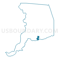
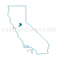
Voting District 51237, Sacramento County, California
About
Outline

Summary
| Unique Area Identifier | 538364 |
| Name | Voting District 51237 |
| County | Sacramento County |
| State | California |
| Area (square miles) | 5.38 |
| Land Area (square miles) | 5.38 |
| Water Area (square miles) | 0.00 |
| % of Land Area | 100.00 |
| % of Water Area | 0.00 |
| Latitude of the Internal Point | 38.26446500 |
| Longtitude of the Internal Point | -121.30063720 |
Maps

Graphs
Select a template below for downloading or customizing gragh for Voting District 51237, Sacramento County, California


Neighbors
Neighoring Voting District (by Name) Neighboring Voting District on the Map
- Voting District 41305, San Joaquin County, CA
- Voting District 51243, Sacramento County, CA
- Voting District 51492, Sacramento County, CA
- Voting District 51501, Sacramento County, CA
- Voting District 51504, Sacramento County, CA
- Voting District 51507, Sacramento County, CA
- Voting District 51510, Sacramento County, CA
- Voting District 51513, Sacramento County, CA
- Voting District 51516, Sacramento County, CA
- Voting District 51522, Sacramento County, CA
- Voting District 51525, Sacramento County, CA
- Voting District 51528, Sacramento County, CA
Top 10 Neighboring County Subdivision (by Population) Neighboring County Subdivision on the Map
Top 10 Neighboring Place (by Population) Neighboring Place on the Map
Top 10 Neighboring Elementary School District (by Population) Neighboring Elementary School District on the Map
Top 10 Neighboring Secondary School District (by Population) Neighboring Secondary School District on the Map
Top 10 Neighboring State Legislative District Lower Chamber (by Population) Neighboring State Legislative District Lower Chamber on the Map
Top 10 Neighboring State Legislative District Upper Chamber (by Population) Neighboring State Legislative District Upper Chamber on the Map
Top 10 Neighboring 111th Congressional District (by Population) Neighboring 111th Congressional District on the Map
Top 10 Neighboring Census Tract (by Population) Neighboring Census Tract on the Map
- Census Tract 94.07, Sacramento County, CA (9,944)
- Census Tract 95.02, Sacramento County, CA (7,055)
- Census Tract 46, San Joaquin County, CA (5,892)
- Census Tract 95.03, Sacramento County, CA (3,067)
- Census Tract 95.01, Sacramento County, CA (2,772)
- Census Tract 95.04, Sacramento County, CA (2,059)
- Census Tract 94.03, Sacramento County, CA (2,038)
- Census Tract 94.08, Sacramento County, CA (1,783)